


Pick Ride With GPS if you build precise routes, need cue sheets, or lead group rides. Pick Komoot if you want fast, surface-aware route discovery for touring or exploring new terrain. Add Strava on top of either for training data and community heatmaps, not for primary navigation. The full breakdown below covers pricing, offline maps, and the exact workflow that gets you the best of both.
TL;DR:
- Ride With GPS is ideal for precise route planning and cue sheets, especially for multi-day tours and organized events, with premium features costing around $80 annually.
- Komoot works best for surface-aware, automated route discovery suited to explorers and touring cyclists, with costs adding up quickly for multi-region trips.
- Offline maps in Ride With GPS are corridor-based, while Komoot offers region packs, impacting choice based on offline needs and route flexibility.
- Strava complements navigation apps by tracking effort and social sharing but is not designed to replace dedicated route planning or offline navigation.
- For most riders, combining Komoot for discovery with Ride With GPS for navigation offers the best workflow, with guided tours like those from Stunning Bike Co-Tours providing a hassle-free alternative.
Every rider asking about Ride With GPS versus Komoot is really asking a deeper question: do you want to architect your ride, or discover it? That distinction, more than any single feature, decides which app earns a spot on your handlebars.
Ride With GPS is built for people who treat a route like a blueprint. It lets you edit waypoints, generate detailed cue sheets, and export files in nearly every format a head unit or paper backup could want. The free basic tier and premium subscription plans run around $80 a year, and that premium level unlocks offline maps, custom cue sheets, and expanded data exports. This is the app audax organizers and touring cyclists reach for when 400 riders need identical, dependable turn cues on the same Saturday morning.
Komoot flips the emphasis. Instead of asking you to draw the route, it builds one for you based on surface type, bike type, and elevation preference. Reviewers consistently describe Ride With GPS as favoring “architects” who want granular control, while Komoot leans toward “explorers” who would rather tap a destination and let the app figure out the gravel-versus-pavement tradeoffs. Komoot’s pricing runs on region unlocks or a worldwide subscription, which suits someone touring one country but adds up fast for a rider crossing several.
Strava does neither job particularly well, and it was never designed to. It excels at logging effort, comparing segment times against friends, and surfacing popular routes through its heatmap. Treat it as the layer that sits on top of your ride, not the layer that gets you through it.
Here’s how the three stack up on the details that actually change your ride:
The pattern holds across every independent test: GearJunkie’s review found Ride With GPS consistently strong on cue sheets and dependable navigation, while Komoot won praise for its simplicity and surface-aware routing. Neither app is objectively “better.” They’re built for different jobs, and Strava was never meant to compete with either one on navigation.
The differences between these apps show up most clearly once you’re actually on the bike, miles from a coffee shop with weak signal and a phone battery dropping faster than expected.
Offline maps work on completely different models. Ride With GPS downloads a corridor, a narrow strip of map data hugging your exact route line. Komoot sells or subscribes you into full region packs, which cover much more ground than you’ll ride but cost more storage and, depending on your plan, more money. For a rider sticking to one planned line, the corridor download is leaner. For a rider who wants freedom to wander off-route and still see the map, the region pack earns its keep. Testing on multi-day bikepacking routes found that corridor downloads reduced the odds of hitting a blank tile mid-detour, a small detail that matters enormously when you’re two hours from the nearest town.
Routing logic is where the planner-versus-explorer framing earns its keep. Komoot’s automated, surface-aware engine will route you around a hike-a-bike section you didn’t know existed, factoring in your bike type and stated preference for pavement or gravel. Ride With GPS assumes you already know where you want to go and gives you the tools to make that route exact down to the meter, with waypoint-level editing that Komoot doesn’t offer.
Navigation reliability separates the two apps further. Komoot’s turn-by-turn voice cues are polished for casual and touring use, and rerouting after a missed turn is generally smooth. Ride With GPS handles rerouting less elegantly but compensates with dependable cue-sheet accuracy, which matters more to riders following a pre-built event route than to someone improvising a Sunday exploration ride.
Battery efficiency consistently favors Ride With GPS on long days. Practitioner testing on audax and multi-day self-supported routes found RWGPS often more battery-efficient than multi-purpose outdoor mapping apps, a real advantage when you’re sixteen hours into a brevet with no outlet in sight.
Exports and community discovery round out the picture:
One statistic worth sitting with: Ride With GPS’s premium tier costs roughly $80 a year, a flat number regardless of how far or wide you ride. Komoot’s region model can beat that price for a single trip, but it’s the kind of cost that creeps up fast for anyone stitching together a multi-state or multi-country tour.
Answer these four questions honestly, and the choice mostly makes itself:
Watch for these red flags before committing to either app for a big trip: Komoot’s region-buy structure getting expensive fast on cross-country routes, an app’s export options falling short of what your head unit or ride leader actually needs, and offline downloads that behave unpredictably once you’re truly off-grid with zero signal.
Pro Tip: Before any major trip, download your offline maps at home on your home Wi-Fi and test navigation in airplane mode for at least twenty minutes. Both apps behave differently once real GPS drift and signal loss enter the picture, and you want to find that out in your living room, not on a mountain pass.
Commuter or casual rider: Build a quick route in Komoot, download a small offline area covering your commute or local loop, and navigate straight from your phone. No exports, no cue sheets, just fast planning and go.
Multi-day tour: Start in Komoot to discover scenic, surface-appropriate routing through unfamiliar territory. Export the GPX file, import it into Ride With GPS, then download the corridor for offline use and generate a cue sheet for your head unit. Practitioners recommend this exact combination: Komoot for discovery, Ride With GPS for the finalization and reliable navigation that follows.
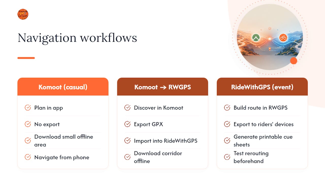
Club ride or organized event: Build the master route in Ride With GPS’s route builder, generate printable cue sheets as a backup, and export the file to every rider’s device ahead of time. Test rerouting behavior on a smaller group ride before race day so nobody gets a surprise.
A few habits protect any workflow: sync your route the night before, not at the trailhead where Wi-Fi is spotty; check Komoot’s region coverage before you buy, so you’re not caught needing a second region mid-trip; and keep your phone screen brightness low while navigating, since screen time drains battery faster than GPS tracking itself does.
Running guided and self-guided tours means navigation can’t be left to chance, and it can’t be a burden on the guest either. Stunning Bike Co-Tours builds routes in advance, tests offline map reliability along Lake Como’s shoreline roads, and pairs that planning with audio-guided helmets that narrate history and points of interest as guests ride, so nobody’s fumbling with a phone screen at a fork in the road.
The results speak for themselves:
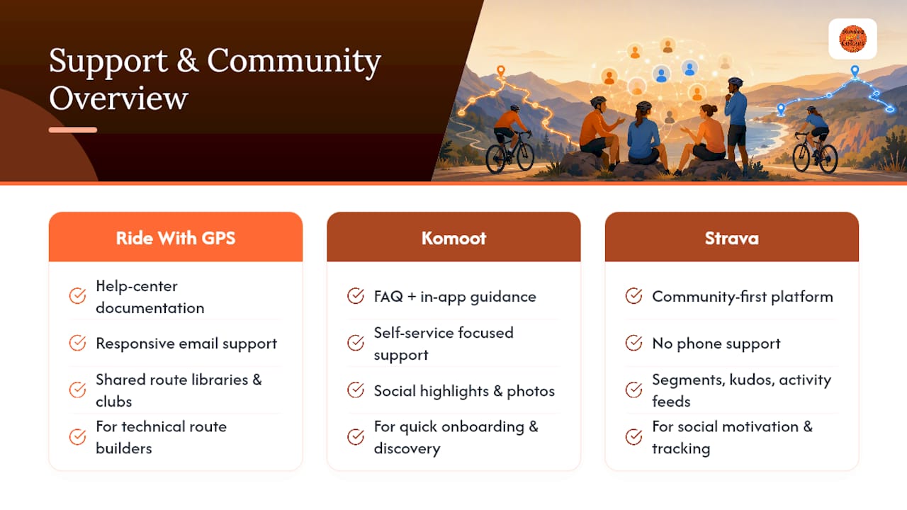
Ride With GPS leans on a documented help center and responsive email support, which fits its audience of route builders who tend to have specific, technical questions about exports or waypoint editing. Its community lives mostly in shared route libraries and club-organized ride pages rather than a social feed.
Komoot’s support model favors self-service FAQs and in-app guidance, matching its simpler, faster-onboarding design. Where Komoot pulls ahead is its social layer: highlights, user photos, and shared route recommendations create a genuinely lively discovery community, though as noted earlier, that density thins out in some regions compared to Europe.
Strava’s community engagement is its whole identity. Segments, kudos, and follower activity feeds make it the most social of the three by a wide margin, even though that social layer has nothing to do with turn-by-turn navigation. If community interaction and public accountability keep you motivated, Strava fills that gap regardless of which app you use to actually navigate.
None of the three apps offers phone-based live support in the way a travel service might. If you want a human to actually answer wayfinding questions in real time on a trip, that’s a role apps generally don’t fill, and it’s part of why some travelers choose a guided or self-guided tour with built-in support instead of troubleshooting an app mid-vacation.
Both Ride With GPS and Komoot collect location and activity data by necessity, since that’s the entire function of a navigation app. Ride With GPS’s account settings let you control route visibility (private, followers-only, or public) and manage what data syncs to connected devices like Garmin or Wahoo units. Komoot follows a similar model, letting you set tours and activities to private by default if you prefer your routes not to appear in public discovery feeds.
Strava’s privacy settings deserve extra attention because its default community focus means more data is public unless you change it. Its “beacon” location-sharing feature and heatmap contributions have drawn scrutiny in the past for exposing rider patterns, including near sensitive locations, when privacy zones weren’t set. If you use Strava alongside either planning app, check your privacy zone settings around your home address specifically. All three platforms publish their own privacy policies detailing data retention and third-party sharing, and it’s worth a five-minute read before syncing any app to a device that also tracks your heart rate or power data, since that health-adjacent data often falls under stricter handling rules than basic GPS tracks.
For casual exploration, Komoot’s automated routing is hard to beat. For clubs, multi-day tours, and anyone who needs dependable cue sheets, Ride With GPS is the stronger tool. Strava earns a place on your phone for training data and community, never as your primary navigator. Most riders do best combining Komoot for discovery with Ride With GPS for the final, offline-ready route, exactly the workflow this guide walked through. Try the free tiers of both before your next trip, or if navigation planning isn’t how you want to spend vacation time, a guided or self-guided tour handles it for you.
— Andrea
Stunning Bike Co-Tours is the alternative for travelers who’d rather spend vacation time riding than debugging offline maps: our routes, audio guides, and support are built in, so you never touch a region-buy screen or a corridor download.
If you’re visiting Como and want the freedom of cycling without the friction of app setup, this is where guided and self-guided options both shine. Every route comes pre-loaded with multilingual audio narration through your helmet, so you get local history and directions without staring at a screen. We’ve served over 4,000 happy customers with five-star reviews on TripAdvisor, and our bikes are checked and maintained before every rental. Worth knowing if you’re navigating Como’s shopping streets: we’re inside a hall of shops, a little tucked away from the main street, but you can spot our storefront by the large window lit up with an LED bike display. Our storefront is distinguishable by a large window lit up with an LED bike display, helping guests identify us easily. Book a bike rental or guided tour and check available dates for your visit, or browse our route guide to see exactly what a Lake Como ride looks like before you commit. For riders planning a longer trip beyond Como, general cycling trip planning guidance is a useful companion resource.
For route architects, club organizers, and multi-day riders who need reliable cue sheets and exports, yes. The premium tier costs roughly $80 a year and unlocks offline corridor downloads and expanded export formats that casual riders may not need.
Komoot offers a free tier with limited region access, and Ride With GPS’s free basic tier covers route planning without offline downloads. Neither free tier matches the paid version’s offline capability, so test both before a big trip.
Komoot sells single-region unlocks as one-time purchases rather than a strict monthly fee, alongside a worldwide subscription option for riders covering multiple regions. Region-based pricing can be cheaper for a single trip but adds up on a route spanning several areas.
It depends on the job: Ride With GPS for precise, exportable routes and cue sheets; Komoot for fast, surface-aware discovery; Strava for tracking and community, not primary planning. Many experienced riders use Komoot to discover a route and Ride With GPS to finalize and navigate it.
If you’d rather not manage either app, a guided or self-guided tour with pre-built routes and audio narration, like the ones Stunning Bike Co-Tours runs on Lake Como, removes that decision entirely.